Forest, Wildlife & Environment Department Government of Gilgit-Baltistan

Forest, Wildlife & Environment Department
Government of Gilgit-Baltistan
Central Karakoram National Park (36.20211N, 75.12163E) established on 1993 in Gilgit Baltistan and it covers an area of 1000000 hectares in five districts i.e., Nagar, Gilgit, Skardu, Ghanche and Shigar. It is largest national park of Pakistan.
The Central Karakoram in the Gilgit-Baltistan of Pakistan is a mountain area endowed with rich biodiversity, natural beauty, and important resources. The Park compasses the world’s largest glaciers, outside the Polar Regions. It was declared as the Central Karakoram National Park (CKNP) in 1993: today it is the largest protected area of Pakistan, covering over 10,557.73 km2 in the Central Karakorum mountain range and the highest park all over the world, it is characterized by extremes of altitudes that range from 2,000 m a.s.l. to over 8,000 m a.s.l., including K2, the second-highest peak in the world. It falls into four administrative districts of the Gilgit-Baltistan Region. In order to facilitate the maintenance of Central Karakoram National Park ecological integrity while, at the same time, providing sustainable management opportunities for local communities and visitors, a zoning system has been implemented. This consists of two main zones, the Buffer Zone and the Core Zone, for a total of 10,557.73 Km2. The Buffer Zone, which is part of the Park and the Core Zone, which includes areas with an higher degree of protection and corridors for tourists with basic facilities. The Buffer Zone (BZ) is supporting a harmonic interaction between nature conservation and the use of natural renewable resources in a sustainable way. This promotes the conservation of landscapes, traditional forms of land use, together with social and cultural features. It is considered a part of CKNP and is spreading for about 2,950.9 square kilometers. It is not continuous around the whole Park, but it is present mainly near the human settlements and near to the areas where there are unsustainable activities and therefore a transition zone is needed. The Core Zone (CZ), with a surface of about 7,606.83 square kilometers aims at preserving a unique ecosystem, representative of the CKNP area. It is populated by important species, where long-term conservation and preservation have to be ensured. On the one hand, this area is impressive both for flora and fauna, on the other hand, the presence of a relevant number of high peaks, many of them over 7.000 m, and glaciers covering about 38% of the whole Park surface, is attracting a relevant number of visitors. To preserve the natural integrity, the Park has designated specific corridors where tourists are allowed to enter, with basic facilities to reduce as much as possible their impact on this fragile, yet highly valuable, zone.
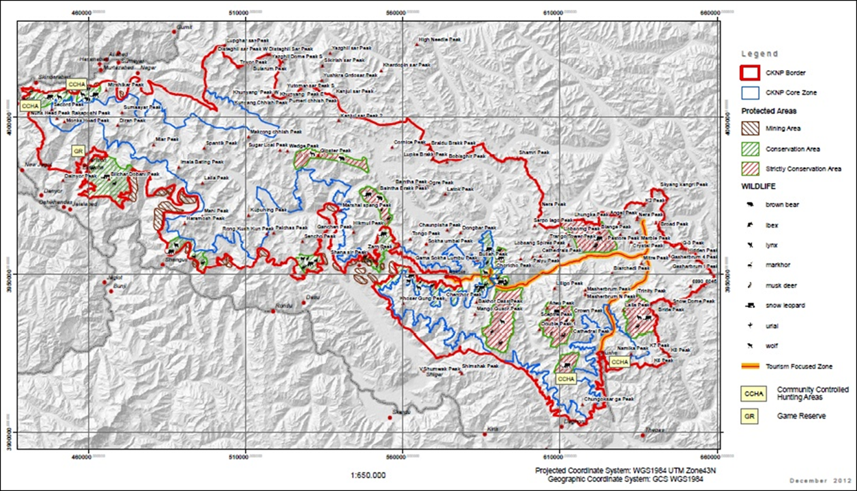
Map of Central Karakoram National Park , Gilgit-Baltistan, Pakistan

Dominant Wildlife and Biodiversity
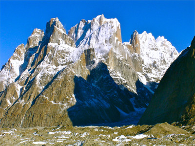
The park is the part of the Central Karakorum mountain range and containing the world’s largest glaciers outside the Polar Regions, along with being the highest National Park in the world. The threatened wildlife species that seek refuge in the grandeur of the vicinity include Snow Leopard, Markhor, Musk Deer, Urial, and Marco polo sheep along with the flag species including Blue Sheep, Ibex, Lynx, and Wolf. Also, approximately 90 species of birds are found here. Over-hunting, habitat loss and isolation of small populations have probably been the main reasons for the bringing the numbers of ‘Snow Leopard’ and ‘Markhor’ close to their biological threshold. Other major attractions include one of the most tectonically-active locations in the world and Biafo, Hisper, Baltoro, and Chogo Lungma make up complex glacial systems in the vicinity. K2, world’s second highest mountain is located in the Central Karakorum Range.
Dominant Fauna
Mammals
Snow leopard
Markhor
Musk deer
Himalayan lynx
Indian wolf
Himalayan ibex
Tibetan Red Fox
Stone Marten
Alpine Weasel
Cape Hare
Kashmir Marmot
Birds
Snow partridge
Chukar
Himalayan snowcock
Himalayan Monal
Common quail
Greylag Goose
Sparrow-hawk
Hen harrier
Beareded vulture
Himalayan griffon vulture
Golden eagle
Booted eagle
Common kestrel.
Mountain Ranges
Northern Pakistan hosts three of the world’s biggest and most spectacular mountain ranges, the Himalaya, the Karakoram and the Hindukush. The convergence of these magnificent ranges, at the confluence of Indus and Gilgit rivers near Jaglot -a small town 40 Km south of Gilgit city-, creates a unique geographical feature.
The Karakoram range covers the borders among Pakistan, India and China, in the regions of Gilgit-Baltistan (Pakistan), Ladakh (India), and Xinjiang region, (China). The range is about 500 km (311 mile) in length, and is bounded on the northeast by the edge of the Tibetan Plateau, and on the north by the Pamir mountains. The southern boundary of the Karakoram is formed, west to east, by the Gilgit, Indus, and Shyok Rivers, which separate the range from the northwestern end of the Himalaya range.
The Western Himalayan range is situated in Kashmir valley and Northern Pakistan, to the south and east of Indus river, and it is dominated by Nanga Parbat massif with highest peak rising 8125 metres above sea level, Pakistan’s 2nd and world’s 9th highest peak. Nanga Parbat peak is also famous for its unique Rupal Face which rises 4,600 meters straight above its base and the mountain is considered as one of the most difficult and dangerous to climb, nick named as Killer Mountain.
The Hindukush rises South West of Pamirs. It is considered to extend from Wakhjir pass at the junctions of the Pamirs and Karakoram to Khawak pass North of Kabul. Its first region extends from Wakhjir pass separating Hunza from Wakhan. Its second region lies beyond Dorah pass in Afghanistan. The third region lies in Pakistan and extends into Swat and Kohistan areas. On the east it is separated from Karakoram by Mighty Indus river. Pakistan’s forth major mountain range, the Suleiman range, emerges in the south western region of the country, mostly covering Baluchistan Province.
In Gilgit-Baltistan, Pakistan the densest collection of highest and precipitous mountain peaks in the world is also found. These includes four, out of the total fourteen, above 8000 meter high peaks in the world, including the second highest mountain – the K2, 8611 m, Gasherbrum II, 8035 m, Gasherbrum I, 8080 m, Broad Peak, 8051 m and sixty peaks higher than 7,000 metres.
The majority of the highest peaks are in the Gilgit-Baltistan region of Pakistan. The area is internationally renowned for mountaineering and trekking opportunities. These mountain ranges also boast more than 160 peaks above 7000 meters and 700 peaks above 6000 meters. It is also the most heavily glaciated part of the world outside the polar regions. The Siachen Glacier at 70 km and the Biafo glacier at 63 km rank as the world’s second and third longest glaciers outside the polar regions.


Vegetation Zones
Alpine dry steppes
Alpine meadows
Alpine scrub
Sub alpine scrub zones
Major Landmarks / Peaks / Lakes
Biafo glacier
Khunyan peak
Rakaposhi peak
K2
Diran peak
Golden peak
Rush lake
Snow lake
Broad peak
Gasherbrum II, III and IV Peaks
Dumani peak
Kutwal Lake
Potential Activities for tourists/visitors

Hiking and trekking

Wildlife sighting

Cycling

Camping

Mountaineering
The details pertinent to Central Karakoram National Park can be view on: https://cknp.org.pk/